In my effots to fill in for my DOI (Dept. of Interior) colleague while he's on vacation, the Joshua Tree NP in Southern California called and asked me to map five fires that burned during July. Based off the lat/long given by the Southern Ops Geographic Area Coordination Center (GACC), three of the five fires all burned on the same Landsat scene (path 39, row 36). Those three also were done burning by July 11, so the July 15 Landsat 5 acquisition was perfect (clouds, location, timing, etc.). I ordered the scene and it came in overnight.
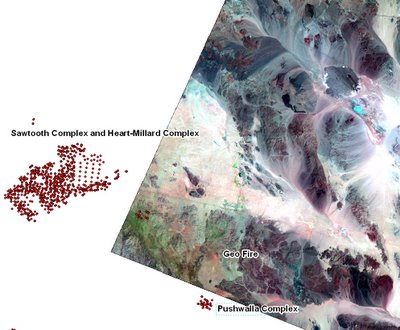
This morning, I imported the image and could only find one of the three fires (the Geo Fire - 740 acres - shown in the image below). I put my cursor over the lat/long provided by the GACC and saw no fire scar. So I turned to the MODIS Active Fire Detections. After loading them over my freshly imported Landsat scene, I learned that the location information for the Pushwalla Complex was incorrect. The fire actually burned 15 km southwest of where the GACC placed it. That's typically not a big deal, but in this case, it meant I had to order a whole new prefire and postfire scene just to capture this 2,200-acre fire! As I write, I'm still awaiting the postfire scene (the prefire was already archived and delivered fairly quickly). That was a little frustrating. And continues to be.
One other note about the image below. Each red dot represents a pixel registered by the MODIS thermal sensor as being an active fire sometime between Jan. 1, 2006 and now. The Sawtooth and Heart-Millard Complexes are to the left. Wherever the dots are spaced far apart or there are areas missing, it could mean one of two things: the fire was fast moving and burned lots of land between satellite overpasses (there are ~4/day between Terra and Aqua MODIS sensors), or clouds interfered and blocked the thermal signature from reaching the sensor. In this case, the fire was very fast moving during a few of the days it burned, creating the linear stretches of fire detections seen here.


No comments:
Post a Comment